In a system where timing is everything, reservoir operators and water managers work behind the scenes to tweak flows for fish
By Allen Best
Those who manage the Colorado River sometimes refer to it simply as the Phone Call. Weekly from late June through October, it lasts an hour, maybe two during perplexing weeks. Fifteen to 20 people, sometimes even 30, participate, reporting plans and voicing needs in an effort to create semi-natural flows in a river system that is anything but natural. Their most basic aim is to recover four species of endangered fish native to the Colorado River Basin that, according to the accounts of early settlers, were nobody’s first choice for a meal. Too many bones!
Meeting target habitat flows set by the U.S. Fish and Wildlife Service for a critical river segment called the 15-Mile Reach, which is directly upstream of Grand Junction, is the essential purpose of the Phone Call, although, since its inception in 1995, the agenda has broadened to other matters.
Today, the Phone Call illustrates the pervasiveness of management in river flows. Here and there, creeks look much as they might have 150 years ago. But in the larger aggregation, little is left to chance. Big dams provide the means to regulate flows, and Colorado’s first-in-time, first-in-right doctrine of prior appropriation furnishes the legal structure for water’s administration.
In the Rocky Mountain state, where most water is already claimed, the Colorado River carries the last reserves of the life-giving liquid. But how much can safely be developed and at what cost?
By Jerd Smith
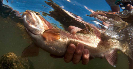
"Dust on snow" causes snow to melt prematurely, before irrigators really need it. Photo by Peter McBride.
Visit any ranch house in Colorado and there is almost always an expansive kitchen table and a wide picture window looking out over the home pasture. Wendy Thompson’s modest ranch house is like that. Backing up to Highway 9 just outside Kremmling, the house faces the hay meadows she irrigates each year. The Thompsons have operated this spread since they were newlyweds. They’ve reared two children here, the view from the picture window changing with the seasons, the coffee pot set in an almost-always-on mode for sisters, nephews, ranch hands and neighbors who gather at the kitchen table.
The ranch draws its water directly from the Colorado River. For years, the meadows flooded naturally in late spring, soaking in the clear, frigid snowmelt flowing down from the Never Summer Mountains. That changed after the late 1950s, when the Colorado-Big Thompson Project, the state’s largest transmountain diversion system, began taking about 230,000 acre feet of water to the Front Range each year. Now such flooding is rare.
In bad drought years, such as 2004, the river ran so low that the Northern Colorado Water Conservancy District, which distributes Colorado Big-Thompson Project water, installed rock berms to raise the water level up to the irrigation structures that Thompson and other ranchers rely on. In a wistful moment, Thompson will tell you she would like to see those meadows flood on their own again, just to know the river had reclaimed some of its former self. “Our children are never going to see this area like it was,” she says.
Thompson spent her childhood on Troublesome Creek, just up the road. Grand County lore has it the creek was so-named for two reasons—old men died trying to cross and they battled endlessly over its supplies. The history of Troublesome Creek has played out again and again on the Colorado River, but never with so many people in the fight and so little water in the stream.
As Colorado faces an increasingly water-short future, it is looking at the Colorado River Basin to determine how much, if any, new water can be set aside and stored to meet the demands of a state population expected to grow from roughly 5 million in 2008 to between 8.6 million and 10 million in 2050. Colorado’s West Slope rivers, all of which feed into the larger Colorado River Basin, are the only rivers in the state that may still have water available to develop, a fact that makes Thompson and others nervous.
Protecting and enhancing water quality on the Colorado
By Jerd Smith
Mesa County and its Grand Valley are the agricultural mecca of the Colorado River Basin in Colorado. Fruit dominates the economy here—and it shows. Endless rows of peach trees, apple trees and grapevines line the highways and back roads. Packing sheds with rusted metal roofs dot the fields, and tall steel towers topped with giant fans stand sentry over the orchards and vineyards, prepared to pull warm air down from the sky to the ground to battle late spring freezes and early fall snow.
In the midst of all this sweet growth, Mel Rettig’s road-side vegetable farm stands out, plain and sturdy, offering corn, tomatoes, green peppers and pinto beans. A faded red and white wooden sign on Highway 141 directs customers back to the vegetable stands behind his home, which sits in the middle of a flat 60-acre spread his father began acquiring in the 1930s. Rettig is at home today, a rarity in the winter. Typically, he and some of his neighbors are on the road, travelling to water meetings in Denver, Glenwood Springs and other points in between—or beyond. He is one of a small posse of de facto, volunteer and self-taught water experts who have worked for decades to understand and master the chemistry of the Colorado River. If you’re a fruit or vegetable grower in the Grand Valley, you’re a water expert or you’re out of business. It’s that simple.
Bound for the delta, through seven states and Mexico
By Jerd Smith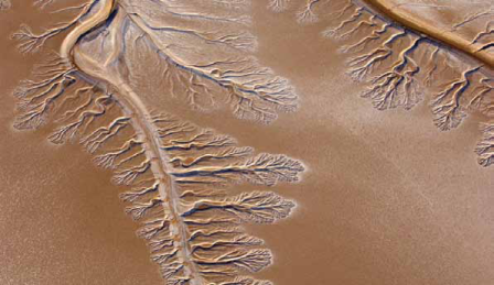
Dendrites indicate the path of rising tides over the mudflats of the Colorado River's Delta at the Gulf of California. Photo by Peter McBride.
Each year, in an ancient ritual, the Colorado River Basin’s mountain watersheds graciously give up their melting snows to the river as it winds some 1,450 miles from its headwaters in Rocky Mountain National Park to the Gulf of California. But while water managers along the river’s path consider increasing demands due to population growth, they’re also expecting the river’s bounty to shrink under the influence of prolonged drought and climate change.
As states and various interest groups stake out their positions, the health of the river itself suffers. “The overarching issues of the main river are often neglected because people are so up in arms protecting their own private Edens,” says Jonathan Waterman, who has traveled the river from its headwaters to its delta and written about it extensively for the National Geographic Society. “Meanwhile, no one seems to put much stock in the fact that the river no longer reaches the sea and hasn’t for more than 12 years."